by Julia Meen

Environmental Archaeologist Julia Meen
I’ve been coordinating environmental sampling out on Zone 6 for the past few weeks. Working in an area of the site with an extraordinarily dense concentration of archaeology of different periods, my job has been to make sure that there is a systematic strategy of sampling in place and to communicate it to everyone digging out there, so that we get a good picture of the environmental conditions at and surrounding the site across the many different time periods which saw humans exploiting this landscape.
With so many time periods represented, and with such a variety of different feature types, the basic aim of the sampling strategy has been to obtain samples from each category of feature (ditch, pit, hole for timber post, etc), and from each period. This sounds straightforward, but in practice turns out to be quite complicated! Fortunately, the use of Geographical Information Systems (GIS) to survey the location of features and environmental samples is a huge help in my task, while on-site spot-dating of pottery is being used to establish to which period a feature belongs.
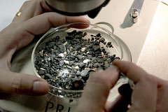
What the people living in each of these different periods at the site – Bronze Age, Iron Age, Roman and beyond – would have had in common is a need for access to a good water supply. On zone 6, this need has left its mark on the visible archaeology in the form of at least five wells. Wells are always an exciting find for archaeologists as they often yield artefacts which have been dropped irretrievably down what can be very deep structures, and for an Environmental Archaeologist they are no less fascinating.
Because wells are dug right down to reach the water table, conditions of permanent waterlogging can be produced in the well bottom, and in this oxygen-free (anaerobic) environment the breakdown of organic plant remains such as wood, seeds and leaves, and of insects including beetles, mites and weevils is inhibited. Much of my time in Zone 6 has been spent ensuring that sufficient samples have been taken from the wells so that we can make the most of this potential for good organic preservation. I have also been employing an auger to drill down through the silted up wells before their excavation is begun, to establish how deep they are. It’s really important that wells are excavated safely, so having this information at the start helps to plan the best way to do this.
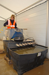
In addition to bulk samples, which will be processed using a flotation tank, I have been taking monolith samples from the wells. These are long, thin blocks of sediment cut vertically from the exposed cross-section of the well, and can be analysed to answer questions about the way in which the material inside the well came to accumulate. I have also taken monolith samples from a number of very deep ditches which cut across the northern part of Zone 6. We hope that these may contain pollen which would tell us what the flora was like in the wider landscape at the time the ditches were open. Since we know that the ditches form a sequence, with later Roman ditches cut through earlier Iron Age ones, looking at the pollen from each period has the potential to tell us how the environment was changing through time – and can suggest whether it was humans who were changing it, for example by cutting down the surrounding trees for agricultural land.