Kent County Council have produced a new video about the East Kent Access Road, featuring Kent’s Principal Archaeological Officer, Simon Mason.
02 SepBronze Age Gold Treasure found
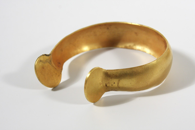
Two Bronze Age gold bracelets almost 3,000 years old have been discovered during excavations along the route of the East Kent Access Road. When they were found one bracelet was placed inside the other.

The two Bronze Age bracelets found on the East Kent Access Road
The bracelets were found in an area of the Ebbsfleet peninsula from which four other Late Bronze Age hoards are already known. Those hoards are all of bronze objects, mainly axes, tools like punches and gouges, fragments of swords, and small ingots.
Although traces of a Late Bronze Age settlement have also been found, the two hoards of axes found in 2004 were shown to be later than the occupation. One theory is that the newly discovered gold bracelets were votive offerings to the gods. Another is that they may have been buried for safe-keeping but never retrieved.
Like some of the previous finds, the bracelets had not been buried in a pit. They were found in the topsoil which suggests that they were either covered by a thin layer of soil or perhaps placed in a bag or other organic container. The findspot lies at the foot of low but locally prominent hill which although it is some way inland today, would have been much closer to the sea in the Bronze Age.
The best parallel for the bracelets, which date to the 9th or 8th century BC, are from two hoards found at Bexley Heath in Kent, which are now in the British Museum.
The bracelets have been reported to the North East Kent Coroner and in due course they will be declared Treasure under the Treasure Act.
-

- One of the Bronze Age bracelets
-

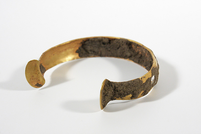
- One of the Bronze Age bracelets, before conservation
-

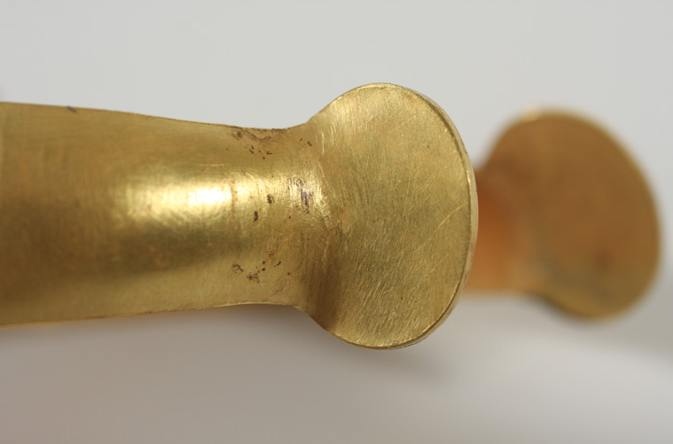
- Detail of one of the bracelets
-

- The two Bronze Age bracelets found on the East Kent Access Road
Video by Kent County Council
27 AugEnvironmental Sampling on Zone 6
by Julia Meen

Environmental Archaeologist Julia Meen
I’ve been coordinating environmental sampling out on Zone 6 for the past few weeks. Working in an area of the site with an extraordinarily dense concentration of archaeology of different periods, my job has been to make sure that there is a systematic strategy of sampling in place and to communicate it to everyone digging out there, so that we get a good picture of the environmental conditions at and surrounding the site across the many different time periods which saw humans exploiting this landscape.
With so many time periods represented, and with such a variety of different feature types, the basic aim of the sampling strategy has been to obtain samples from each category of feature (ditch, pit, hole for timber post, etc), and from each period. This sounds straightforward, but in practice turns out to be quite complicated! Fortunately, the use of Geographical Information Systems (GIS) to survey the location of features and environmental samples is a huge help in my task, while on-site spot-dating of pottery is being used to establish to which period a feature belongs.
What the people living in each of these different periods at the site – Bronze Age, Iron Age, Roman and beyond – would have had in common is a need for access to a good water supply. On zone 6, this need has left its mark on the visible archaeology in the form of at least five wells. Wells are always an exciting find for archaeologists as they often yield artefacts which have been dropped irretrievably down what can be very deep structures, and for an Environmental Archaeologist they are no less fascinating.
Because wells are dug right down to reach the water table, conditions of permanent waterlogging can be produced in the well bottom, and in this oxygen-free (anaerobic) environment the breakdown of organic plant remains such as wood, seeds and leaves, and of insects including beetles, mites and weevils is inhibited. Much of my time in Zone 6 has been spent ensuring that sufficient samples have been taken from the wells so that we can make the most of this potential for good organic preservation. I have also been employing an auger to drill down through the silted up wells before their excavation is begun, to establish how deep they are. It’s really important that wells are excavated safely, so having this information at the start helps to plan the best way to do this.
In addition to bulk samples, which will be processed using a flotation tank, I have been taking monolith samples from the wells. These are long, thin blocks of sediment cut vertically from the exposed cross-section of the well, and can be analysed to answer questions about the way in which the material inside the well came to accumulate. I have also taken monolith samples from a number of very deep ditches which cut across the northern part of Zone 6. We hope that these may contain pollen which would tell us what the flora was like in the wider landscape at the time the ditches were open. Since we know that the ditches form a sequence, with later Roman ditches cut through earlier Iron Age ones, looking at the pollen from each period has the potential to tell us how the environment was changing through time – and can suggest whether it was humans who were changing it, for example by cutting down the surrounding trees for agricultural land.
17 AugA Day in the Life of Finds Processing
Oxford Wessex Archaeology finds specialist Janice McLeish writes about a typical day processing finds on the East Kent Access Road excavations:
Morning all,
A typical day (if such a thing exists in the finds cabin) consists of arriving around 8am and weighing in the bulk finds and small finds that have been recovered on site the day before. Once retrieved from under tables, behind chairs, or on desks the job begins.
On every archaeological site each feature (such as a pit, ditch or posthole) is given a unique number and the layers in those features are also given a unique number so that any finds recovered from any layer of any feature can be isolated. The road scheme is divided into over 20 zones to keep it simple!
Every incoming bag, box, bucket of finds is checked to make sure all the relevant information is provided. The context numbers used on this site also contain a prefix number which relates to each individual archaeologist and we have the list of who’s who.
Once sorted the finds are weighed in and tagged with zone number, weight and date, this helps the finds supervisor Ellie keep track of how much material is arriving and being processed. The finds are then separated into bulk finds (general material) and small finds (especially interesting objects). The small finds would normally be given an additional number called an object number and separated depending on material type (generally metals and non-metals).
The next challenge is finding storage space for the new finds until they get washed. The processing – washing, drying and marking – is being helped along by our loyal volunteers who don’t mind washing rather a lot of burnt flint, which is an important, if repetitive part of the site archive!
Throughout the day we also do data entry, so every item that’s been processed including small finds has to be recorded and entered onto the site database. Its great when you get the chance to handle and record something that’s not been seen or touched for thousands of years, this happy glow helps you survive the darker moments of counting hundreds of marine oyster shells and whether they’re left or right valves and if they’re measurable or not (someone mistakenly thought I was recording if they were miserable or not).
No two days are the same in the finds cabin and this makes for a great working environment, and I am very appreciative to have been given the opportunity to see such diversity of material and have such a hands on role, so thanks Ellie for making me enjoy my job so much.
Time to go home now and personal highlight is getting through today without chipping my newly acquired ‘nail art’ (culmination of girly night out last night).
See you tomorrow
Janice McLeish
29 JulSpot dating at Zone 6 of the East Kent Access Road

Paul Hart identifying sherds
Zone 6 of the East Kent Access road scheme, situated along Ebbsfleet Lane, has provided us with the greatest concentration of archaeological features yet seen on this project. It is also the most concentrated area of multi-period activity that I have seen during nearly twelve years of exploring Thanet’s wonderful archaeological heritage.
Inspired and helped by Kent pottery analyst Nigel Macpherson-Grant, I’ve been trying to get to grips with the pottery sequence in East Kent for some years now and I was delighted when Paul Murray asked me to do some preliminary spot-dating of the pottery coming out of the excavations on Zone 6. A great opportunity for me to learn more; a brave and bold strategy by Oxford-Wessex!
The archaeologists working hard and under strict time-pressure on Zone 6, have already uncovered wonderful things. With regards to the pottery, the earliest pottery identified so far dates to the Middle Bronze Age circa 1550-1350 BC. Peter Cichy discovered a virtually complete inverted urn of classic Middle Bronze Age style. A slightly unusual rim sherd from a large vessel of potentially the same date was recovered from a nearby ditch by Pete Lovett. Importantly, these two vessels might have been decorated using the same tool and this may provide us with a rare opportunity of identifying vessels made by the same prehistoric potter! Further work is required however.
Some of the pottery may give evidence of activity in the Late Bronze Age and Earliest Iron Age c.1100-600 BC, though certainly identified sherds are few at present and, again, more work is required. A major burst of activity occurred during the Early-Mid Iron Age c.550-350 BC and the quantity of pottery recovered suggests that it was at this time that the area of Zone 6 first became the focus of an actual settlement. From this period onwards the pottery evidence suggests that there may have been a relatively constant presence of human settlement activity, through to the Late Iron Age, Roman Conquest and Roman periods.
Ditches, pits and post-holes attest to the different phases of activity and it is the presence of a settlement which may have existed at the time of the Roman Conquest which could prove to be of particular significance. The archaeology in Zone 6 may allow us to perceive the evolution of a multi-period Iron Age site, influenced by contacts with the Continent, to a Late Iron Age site influenced by a more Romanised Continent, to a settlement which may have seen the arrival of the Romans in Kent. How this settlement was organised in the Early Roman period, along with the changes in the pottery and the other artefacts that remain, may allow us some important insights on how and to what degree the Roman world influenced the Iron Age inhabitants of this significant location on the Isle of Thanet.
Late Roman pottery of at least c.250 AD in date has been recovered, but at present the majority of the ceramics appear to date to the Earlier Roman period, perhaps particularly the 2nd century AD. Coins of 4th century AD date have been identified by Simon Holmes, so some degree of Late Roman activity continued in this area. A single sherd of c.7th century AD Anglo-Saxon pottery has been recovered from a post-hole and this is at present the most recent piece of pottery yet identified from Zone 6.
Paul Hart 24/25.07.10
29 JulExcavating a Romano-British oven
By the Western edge of the excavation area at Zone 6 of the East Kent Access Road scheme a promising extensive rectangular feature (approx. 10 x 10m), surrounded by a ring ditch, was uncovered. Regarding the large size of the feature and the characterisation stage of the excavations it was decided that we will excavate initially only one metre wide strips of the South-East quadrant. Our choice of slot location appeared to be quite a fortunate one – soon my trowel ‘hit’ the top of an oven wall.

Excavating an oven
Due to fragility of the structure a decision was made to extend the slots allowing for exposure and recording of the whole oven before it deteriorates any further. When fully uncovered, it turned out to be a beautiful piece of work – with a base made of chalk stone arranged in concentric circles and covered at places with a fired clay lining, or surface. On top of that sat fired clay wall remains, now measuring only up to 0.18m. The walls leaning toward the centre suggested the original beehive shape of the oven. The structure – 1.36m in diameter – had its mouth at the North-East, which after the last use was sealed with sandstone slabs and clay. The fire pit was located externally. Both the oven and the feature it was found in – produced a substantial amount of pottery sherds, dating the oven to the Romano-British period.
Usually we don’t have full understanding of the purpose these ovens served. However, regarding lack of slag or pottery in situ, we suppose it was used for processing food – i.e. bread baking. This is an ongoing investigation and we hope to produce more detailed interpretation once the environmental samples have been processed.
Milena Grzybowska
29 JulExcavation of a metalled trackway

Excavating the metalled trackway
We began work investigating a large area of dark soil and patchy surface metalling. A 7m by 4.5m slot was excavated. Working from South-East to North-West we initially exposed compact metalling consisting of small to medium dark rounded pebbles. Occasionally animal bone was set within the metalling and in one area disarticulated human bone consisting of a large skull fragment, vertebrae and other bone fragments. Immediately adjacent to the skull a curved iron object was found, either an Iron Age bill-hook or sickle. Though the distribution of both human and animal bone has been suggested as being ritual it would appear the animal bone was used as part of the metalling surface which formed a substantial trackway. Wheras it is currently unclear whether the human bone has been used in the same way or originates from the spread of dark soil above.

Overhead view of the trackway under excavation
The metalled trackway was cut by two North-East to South-West aligned ditches of Roman date. Two rounded pits to the North-West appeared to be cut by one of the ditches but further investigation is necessary.
Kirsty Bone
Laura O’Shea
22 JulVideo: Pieces of Thanet’s Past
Archaeologist David Crawford-White tells YourThanet reporter Tom Betts about what has been found while the building of the East Kent Access Road gets underway.
Filmed at Westwood Cross, Sun, March 28, 2010.
14 JulArchaeology of the East Kent Access Road Podcast (part two)
Archaeocast visits the site during one of our July 2010 Open Days to find out about what has been found so far. Hear from our specialists about prehistoric flint tools and how we learn about past environments, find out what some of our volunteers have been up to, and go on a site tour of a late Iron Age village.
Listen to our first podcast now by clicking the play button below, or subscribe to Archaeocast with iTunes to get future updates automatically.
Archaeocast: The East Kent Access Road (Part Two)
Listen to more archaeology podcasts from Wessex Archaeology’s Archaeocast.
13 JulWhat is environmental archaeology?
Archaeobotanical flot sorting
Environmental sampling is essential for the recovery of small plant and faunal remains such as cereal grain, chaff, insects, molluscs and small bones. The study of these remains can provide vital information on factors such as economy, agriculture, diet, trade and the environment of past settlements.
The environmental processing has been ongoing throughout the excavations on the East Kent Access Road. Generally samples are taken from features which are thought to have a high potential for environmental remains, and are then brought back to the compound for us to process. The standard size for a sample taken for charred remains is 40 litres. The samples are floated in a modified flotation tank, which allows any preserved plant remains and molluscs to float and be collected on a fine mesh, known as the flot. The remaining residue is sieved through graded meshes. The flot is then allowed to dry and scanned under a binocular microscope in order to determine the presence and preservation of charred plant remains. The dried residues are scanned by eye, with any surviving bones or artefacts retained.
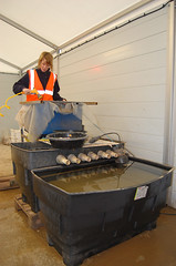
Processing soil samples
The samples we have processed from this site have been very varied and have displayed a good range of material and will eventually, when fully analysed, be able to provide a good environmental reconstruction of the site. The preserved plant remains from the samples have all been charred (with the exception of a few mineralised examples) and will be able to provide information on land use, agriculture, trade and economy. The mollusc preservation has been varied, with the sites on the calcareous zones providing a much larger assemblage of well preserved molluscs than those sites on brick earth or Thanet Sands. Because molluscs are very indicative of the environments in which they live, the analysis of these assemblages will help us to build up a picture of environment and landscape change through the different periods of the site.
Environmental processing can often be a very wet and muddy job! It can also be very varied, with one sample containing the burnt remains of a disused hearth, and the next sample containing a layer (complete with poo!) from a Roman cess pit. Processing the samples on site has its advantages, as we can swiftly identify the features which are providing productive remains, and target them for future sampling. Processing and analysis of the samples will continue for some time after the excavation has finished.
Laura Stafford
